


If you've ever wondered how certain businesses seem to be everywhere at once or how your favorite delivery app knows the shortest route to your doorstep, you've seen the magic of geospatial data at work.
Geospatial data may sound complex, but at its core, it's all about location and related information.
Imagine it as a digital map that holds the answers to questions like "Where?" and "What's there?" It's the key that connects places, people, and things, allowing businesses and experts to make smarter decisions.
At its heart, geospatial data is about places. It tells us where things are located on our planet, whether it's your favorite coffee shop, a rare species' habitat, or a shipping container en route to its destination.
Geospatial data is also sometimes referred to simply as "Spatial Data", "Geographic Information", "Geographic Data" or "Location Data". But it's more than just coordinates; it's a dynamic record of what's happening in those places – from traffic patterns and weather conditions to land use and population density.
In this article, we're going to demystify geospatial data. We'll break down its definition into simple terms and show you how it's used in the real world. Geospatial data plays a crucial role in diverse fields. So, if you're curious about how maps and data come together to shape our world, keep reading.
What is Geospatial Data?
Geospatial data refers to information about objects, events, or phenomena that are associated with a specific location on the Earth's surface. This data often includes coordinates like latitude and longitude and can be used for mapping and spatial analysis.
In fact, it describes both the physical location (often using coordinates like latitude and longitude) and the attributes of that location. For example, a data point might not only pinpoint the location of a lake but also detail its depth, the type of fish it houses, and its proximity to nearby landmarks.
More than just a 'where' dimension, geospatial data incorporates the 'what' and 'how' associated with that 'where'.
This rich depth of information is what differentiates geospatial data from generic data. Its value lies in its ability to combine location-based insights with qualitative and quantitative attributes, offering a multidimensional perspective of the world around us.
Types of Geospatial Data
Spatial data can be primarily categorized based on how it represents geographic information. The two main types are Vector Data and Raster Data. However, an added dimension of time can further refine these categories, introducing temporal dynamics into the mix.
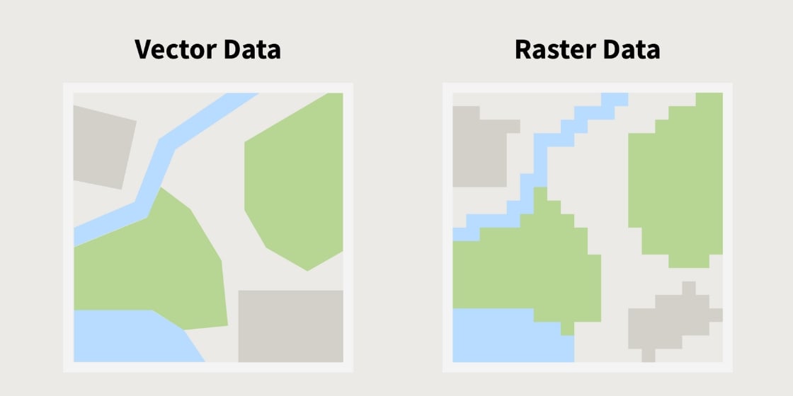
Vector Data
Vector Data is a type of spatial data representation using points, lines, and polygons to depict discrete locations, shapes, and attributes of geographic objects.
Vector data is based on geometric shapes to represent features on the Earth's surface. It breaks down into 3 main components:
- Points: These represent specific, singular locations on the Earth. Examples include the location of a landmark, such as a monument or a water well.
- Lines: Linear features like rivers, roads, or pipelines are represented using lines. Each line is essentially a series of interconnected points.
- Polygons: Areas or regions, like lakes, forests, or urban boundaries, are represented by polygons. These closed shapes encapsulate a particular space and often detail its attributes, like area size or soil type.
Raster Data
Raster Data is a grid-based data format that captures continuous phenomena, where each pixel or cell has a value representing information, such as elevation or temperature, for a specific location on the Earth's surface.
Raster data, in contrast to the clean geometries of vector data, comprises pixels. Each pixel within this grid-based format has a specific value, which could represent various continuous elements:
- Images: Think of satellite imagery or aerial photographs, where each pixel might represent a color or shade.
- Maps: Topographic or thematic maps often use raster data to indicate variations, like changes in elevation or land use.
- Continuous Data Layers: These layers could showcase temperature, precipitation, or pollution levels, where each pixel's value indicates the intensity or magnitude of that particular attribute.
Temporal Component: Spatio-Temporal Data
When a time element is integrated into geospatial data, it becomes spatio-temporal. This type of data doesn't just detail where something is or what its attributes are but also when those conditions apply.
For instance, a spatio-temporal dataset might track the migration patterns of a particular bird species, noting not just where they travel but also the specific times of year they occupy different regions. Similarly, in urban planning, spatio-temporal data can show how traffic patterns evolve throughout the day or how pedestrian movement changes with different events or seasons.
Incorporating time into geospatial data provides a dynamic layer of understanding, enabling predictions, trend analyses, and a richer comprehension of changes and developments. Whether it's monitoring deforestation over decades or analyzing hourly fluctuations in urban air quality, spatio-temporal data bridges the gap between static information and evolving realities.
Sources and Collection Methods for Geospatial Data
The advancement of geospatial technology has dramatically expanded our capabilities to collect geospatial data.
The sources of geospatial data are varied, and the methods used for geospatial data collection have evolved dramatically with technological advancements.
Here's an overview of both the origins and collection techniques of this invaluable data.
- Government Agencies: Many governmental bodies release geospatial datasets to the public, often as part of open data initiatives. These datasets can include information on land use, transportation networks, demographic statistics, and more.
- Satellites Imagery: These orbiting bodies capture vast amounts of geospatial data, especially through remote sensing technology. They provide images of the Earth's surface, atmospheric data, and other spatial information at various resolutions.
- Aerial Surveys: Aircraft equipped with cameras or sensors can cover large areas in relatively short periods, making them ideal for capturing topographical details, vegetation patterns, and urban structures.
- Private Companies: Numerous firms specialize in collecting and selling geospatial data. These specialised data providers range from companies that operate satellites to those that create detailed street maps or indoor building schematics.
- Community-Driven Projects: Projects like OpenStreetMap rely on contributions from individuals around the world. This crowdsourced data can provide detailed local insights and up-to-date information.
- Sensors and IoT Devices: The proliferation of connected devices, from wearables to vehicle sensors, is generating vast amounts of location-based data, offering granular insights into various phenomena.
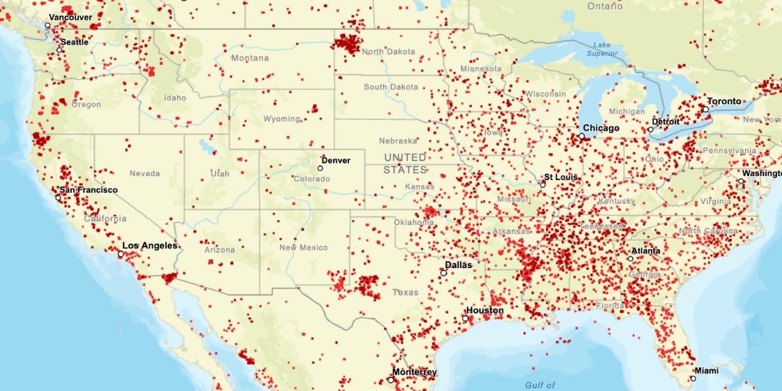
Infobel PRO and Geospatial Data: Excellence in Address and Building Management
At Infobel PRO, we take pride in the quality of our data. We have put in place advanced methods and processes to obtain, transform, improve and refine address and building management data, guaranteeing granularity and accuracy.
Address management is more than just pinpointing a location on a map. At Infobel PRO, we understand the layers of complexity and importance behind every address. When processing address data, we not only identify its geospatial coordinates but also associate it with relevant attributes like building surfaces, business name, sector of activity, and more.
All our location data is geocoded to ensure that addresses can be translated into geographic coordinates and vice versa.
Our algorithms are designed to recognize inconsistencies or errors in address data, such as duplicated entries or outdated information. By doing so, we ensure that the address data we provide is both accurate and actionable.
Providing Advanced Geospatial Data Solutions
Infobel PRO's geospatial platform is intuitive and user-friendly, designed with businesses in mind. Our clients can access a comprehensive database of addresses, complete with associated geospatial data like coordinates, building geometry, attributes, and more.
All our data is also available in GeoJson files that can be easily used in the most popular geographic information systems software.
Moreover, we're continuously expanding our dataset, adding more attributes and refining existing data. This ensures our clients always have access to the most up-to-date and comprehensive geospatial data available.
Geospatial Data Analysis
To analyze spatial data, especially with its intricate details and vast volume, requires a rigorous process of analysis to yield actionable insights. This process, rooted in data science and often facilitated by data scientists, combines a multitude of techniques and methods to decipher patterns, predict trends, and make informed decisions.
Spatial data analysis requires a rigorous analysis process in order to obtain usable information.
Predictive Modeling
Harnessing machine learning and artificial intelligence, it's possible to forecast spatial events or behaviors. This might involve predicting urban development trends, potential wildfire paths, or the spread of an environmental contaminant.
Network Analysis
This involves examining the connections and pathways within the data. One might study the flow of traffic through a city, optimize delivery routes, or analyze the distribution of utilities across a region.
Terrain Analysis
Topographical data offers insights into elevation, slope, and other landscape features. Such analysis is integral in fields like agriculture, urban planning, and environmental conservation.
Integration with Other Data Types
Geospatial analysis often becomes richer when intertwined with other types of data. Combining spatial data with demographic or economic data, for example, can offer a more comprehensive picture of a region's dynamics.
Spatial Statistics
Spatial data is not just about location; it's about understanding the relationships and patterns inherent to those locations. Techniques like Moran's I or Getis-Ord Gi* are employed to identify spatial clusters or anomalies.
Visualizing Geospatial Data
Effective geospatial analysis requires robust visualization tools. Representing data through heat maps, 3D models, or interactive dashboards can make the information more accessible and intuitive.
Tools for Geospatial Analysis
Many software options cater to geospatial data analytics and processing:
- GIS (Geographic Information Systems) Software: Platforms like ArcGIS or QGIS are staples in the field, allowing for data storage, analysis, and visualization.
- Programming: Languages such as Python and R have specialized libraries that cater to geospatial analysis needs.
- Cloud Solutions: Handling large datasets efficiently is made easier with cloud platforms, such as Google Earth Engine.
The process of turning raw geospatial data into meaningful conclusions is a blend of art and science. Whether it's urban planners deciding the best location for a new park, or environmentalists tracking deforestation, geospatial analysis is at the heart of these decisions.
Geospatial Data: Examples of Use
Geospatial data has been employed across various industries and sectors, offering precision and a comprehensive view that's essential in today's decision-making processes.
Central to its functionality is geocoding, which translates user-inputted addresses into precise geographic coordinates, and vice versa, enhancing its usability and accuracy. Here are 7 diverse applications:
Mapping and Points of Interest (POIs):
Geospatial data is fundamental in modern map creation, enhancing them with dynamic Points of Interest (POIs). Whether it's pinpointing restaurants, historical landmarks, or available real estate, geospatial data ensures accurate and interactive mapping. As users navigate these maps, they can access detailed information, from operating hours of a cafe to reviews of a local museum, making maps not just about direction but also about discovery and engagement.
Urban Planning and Development
City planners use Spatial data to make informed decisions about infrastructure, zoning, and land use. By analyzing current spatial patterns and predicting future trends, they ensure sustainable growth and optimal land utilization.
Retail and Business Analytics
Businesses, especially in the retail sector, leverage geospatial data for location-centric analytics. By understanding consumer patterns, regional demographics, and the locations of competitors, they can choose optimal sites for new outlets or target marketing campaigns more effectively.
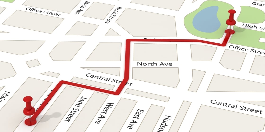
Transportation and Logistics
Geospatial data aids in optimizing routes, reducing fuel costs, and ensuring timely deliveries. Public transportation agencies also employ this data to design new routes, assess infrastructure needs, and observe traffic patterns.
Natural Resource Management
Geospatial data plays a pivotal role in managing and conserving natural resources. By analyzing spatial patterns of resource distribution and consumption, stakeholders can make informed decisions to ensure sustainable utilization and conservation.
Disaster Response and Management
In the wake of natural disasters like hurricanes or floods, geospatial data plays an essential role in response efforts. By assessing the damage and identifying affected areas, first responders can allocate resources more efficiently. Furthermore, weather data can be instrumental in predicting the course and impact of ongoing or imminent natural events.
Agriculture and Precision Farming
Farmers today harness geospatial data to optimize their yields. Through remote sensing, they can monitor soil health, track crop growth, and anticipate potential pest infestations. This leads to better yields and sustainable practices.
Challenges and Concerns with Geospatial Data
Like any powerful tool, geospatial data isn't without its challenges:
- Data Accuracy: Not all geospatial data is created equal. Some datasets might be outdated or have inaccuracies. Ensuring data quality is crucial for making informed decisions.
- Privacy Concerns: As geospatial data can pinpoint specific locations, there's always a concern about infringing on individual privacy, especially in densely populated areas.
- Storage and Management: The sheer volume of geospatial data, especially with high-resolution imagery, requires robust storage solutions and efficient management practices.
Conclusion
Geospatial data stands at the crossroads of technological innovation and real-world applications. Whether it's guiding a delivery driver through the maze of city streets, assisting urban planners in crafting sustainable cities, or empowering retailers to strategically position their outlets, the power of geospatial data is evident.
The information it provides, enhanced with temporal aspects, can be dynamic and predictive, offering a multidimensional view of the world. Tools and technologies, from GIS software to cloud platforms, aid in harnessing this data, translating it into actionable insights.
However, like all potent tools, it comes with challenges like ensuring data accuracy and addressing privacy concerns. As we stand on the cusp of an even more interconnected world, the importance of geospatial data, its collection, management, and analysis, is bound to grow, influencing myriad aspects of our daily lives and long-term strategic decisions.


Comments